2016-05-10

Nice fishing at Bryson Lake Lodge


Last year we had an opportunity to visit Bryson Lake Lodge in upper Pontiac. It was mid-May, and still chilly — but that also meant that the normal seasonal onslaught of black flies had not yet started. The hunting and fishing clientele would not be challenged by the many kilometers of gravel road leading to the well-equipped lodge and cabins, but we were glad to have good clearance in some particularly rough stretches of road.

When the operator, Denis LeBrun, took us out on a nearby lake to catch some brook trout, I fully expected the event to be like almost all of my somewhat limited fishing experiences: chilly waiting for very brief excitement as the hook becomes snagged — and hamburgers for lunch.

Not this time! Within moments, Katharine had caught a decent-sized brook trout — and then another, and another... All three of us pulled in several fish in short order, then spent an hour or so chatting as we quietly cruised around small Lac de l’Enclume (thanks to Denis’ electric trolling motor).

I captured this photo sphere as Katharine and Denis took the gear to his vehicle.


Lac de l’Enclume, near Bryson Lake Lodge in upper Pontiac, by Eric Fletcher

Fresh brook trout for lunch!
It was hard to beat the freshness of a couple of these brook trout for our lunch. The rest were wrapped in ice to take home to share later that evening with friends.

I was intrigued to see that this particular photo sphere (and two others taken nearby) has had  many more views than others taken in what would seem to be more popular locations.

However, if you look at this region on an app like StreetView, it looks virtually empty, with just a few rivers and lakes — and almost no imagery at all. I assume hunters and fishers will know that is their type of territory, so they will notice the few images available and click to open them.

Another interesting lesson in the benefits of geotagged imagery...
2016-05-09

Jane’s Walk 2016


Katharine has been leading a Jane’s Walk at the Central Experimental Farm for many years now. The walk is an hour in early May, and always starts at the Dominion Observatory Building. The buildings are no longer open to the public, and the telescope was removed in 1970 — but the cluster of three buildings are a nice reminder of how this was once in the outskirts of the old city.

A plaque on the west side wall notes the official Canadian prime meridian: 05H 02M 51.940S west of Greenwich. After missing a train in Ireland in 1876 due to confusion over a.m. and p.m. on the schedule, Sir Sandford Fleming proposed a single 24-hour clock system. To allow for a local time, he proposed dividing the globe into time zones, with the 0° meridian of Greenwich, England, being the Coordinated Universal Time (UTC).

The main observatory building was completed in 1905, and its 15" refracting telescope was initially used for detailed astronomical timekeeping to support surveying. The smaller domed building to the SE of the main building is the Photo Equatorial Building (building #9), and had a camera for photographing stars. On the SW side, the South Azimuth Building (1912) contained a telescope and a meridian pier to act as a reference point for surveying work.


Dominion Observatory at the Central Experimental Farm in Ottawa, by Eric Fletcher

I captured this photo sphere at the end of the 2016 Jane’s Walk on a lovely Saturday afternoon. The trees were just starting to bud, and ~20 people had enjoyed the hour-long guided walk.

2016-05-08

Photo spheres at night


The light gathering capability of my Nexus 6P is quite remarkable, and can capture decent imagery in near-dark conditions. However, I had not tried capturing a photo sphere at night with it until recently.

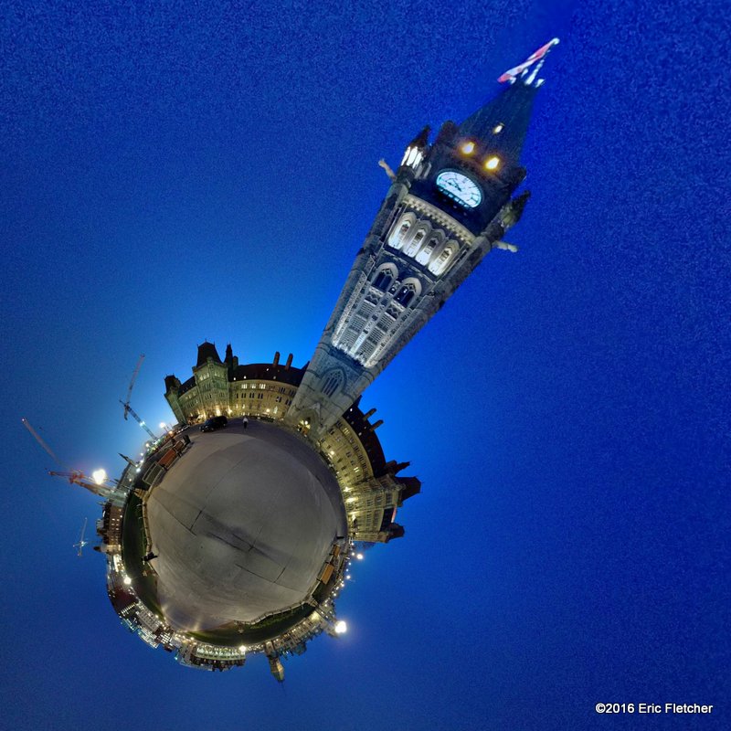
We were in Ottawa for an event last week, and took advantage of the mild evening to stroll around a nearly empty Parliament Hill. As an RCMP officer in a parked cruiser looked on with more-than-casual interest, I did my slow rotation to capture this image.


Parliament Hill at night, by Eric Fletcher

Not bad. There is certainly some graininess, but I think it captured the mood quite well. The Parliamentary precinct has several major renovation projects underway; ergo the construction cranes.

This second photo sphere was taken a few metres away at the top of the grand staircase leading to the front door of the building.


Parliament Hill from the main entry stairs, by Eric Fletcher

The RCMP officer’s black SUV can be seen in this image.

The Android camera app allows me to create a “tiny planet” image from a photosphere. This is a rendering from the above photosphere (click it to see the full square view):

Fun eh?

2016-04-25

New camera for Photo Spheres


A trip we’re planning for this coming summer triggered me to replace my Nexus 7 tablet with a newer device with a better camera and cellular capability. Specifications enabled me to narrow my choice to either the iPhone 6 Plus or Nexus 6P, but the Nexus 6P’s camera functions tipped the balance in its favour.

The Photo Sphere function I’ve been using in the N7 tablet’s native camera app does a decent job, but the faster processor and additional sensors in the Nexus 6P make quite a difference. Instead of ~2 minutes to capture and about the same to process, the N6P takes ~45 seconds for each stage — and the stitching is significantly better. In the photosphere below, just a part of the road sign and a mis-matched rail very close to where I had been standing show any stitching errors. With the Nexus 7, any more than a slight tilt as the camera captured the frames would result in stitching errors even on distant objects.


Bridge over the upper Quyon River in Thorne. by Eric Fletcher

This post also tests a new method I’ve discovered to embed a photosphere directly into a blog post.

In the above image, click and drag within the image to move it around and up & down; click the +/– buttons or Ctrl-Roll the mouse to zoom in & out. Click on the expand button in the upper right corner to show the view full screen without leaving this blog page.

Links within the box in the upper left corner will open new browser tabs: my name opens to my G+ public profile; the marker icon opens Google Maps to the photosphere's location; and the “View in Google Maps” link will display it in a full Maps window.

Unfortunately, the embedding method is not particularly straightforward. I first copied the Google Maps photosphere URL, and then used Herman Stankov’s GitHub code (here) to create a very basic HTML “page” to load to my website. I then used Tony Redhead’s tip (here) to reference the page within an iFrame code snippet that embedded into this blog post.

Note: this method relies on the unique pano id embedded within the Google Maps URL. I can only assume that it would not be in Google’s interests to cancel the pano id because it would make the link invalid here and in their StreetView and Maps products.

2015-09-14

Photosphere along the Shackleton Hike in South Georgia


In August, Google eliminated Maps View to roll it (and Panoramio) into their Google Maps product. It was probably a reasonable business decision, and will likely result in more people viewing contributed images and photospheres — but it eliminated the easily-accessible stats about view counts, and alienated many dedicated contributors.

More puzzling was their decision to eliminate the descriptive text most contributors included with imagery. All of my images had captions — some as several paragraphs — to provide a context for the image. Captions for well-known places may have been considered redundant, but I would argue that they were (are) essential for remote locations.

Fortunately, I have backups of my contributed imagery — and they still include the captions. To ensure the information is not lost forever, I’ll post selected ones on this blog, with a link to where they can be seen in Google Maps.

Along the Shackleton Hike, South Georgia
[click to open as a photosphere in Google Maps]
I captured this photosphere in December 2013 while participating in a hike that followed the final leg of a route across South Georgia Island taken by explorer Sir Earnest Shackleton in 1916. Here is the caption I originally included with the contributed image.

Along the Shackleton Hike, South Georgia.

Passengers from the MV Fram take a half-way break on a 6km hike between Fortuna Bay and Stromness Harbour.

These conditions were pleasant compared to the bitter cold and snow faced by explorer Ernest Shackleton and 2 companions in 1916. After enduring 17 days and 1300 kms in a small boat, they had landed in a bay on the uninhabited western side of South Georgia This was the final leg in a grueling 42km hike to get help from whalers at Stromness Harbour.

This hike was one of many shore excursion options during Hurtigruten’s “Realm of the Great Explorers” 19-day expedition. Although it did involve some clambering over loose rock, and a descent through snow, the hike was not particularly challenging. Although I had brought hiking boots, I chose to use the neoprene boots from the MV Fram: they were warm and kept my feet dry — and with no blisters.